GTA 6 map: YANIS reconstruction, Rockstar's poster and interactive markers
Compare the YANIS V16 GTA 6 map, Rockstar's Leonida poster and State of Leonida's interactive map, with sources, version differences and limits of accuracy.
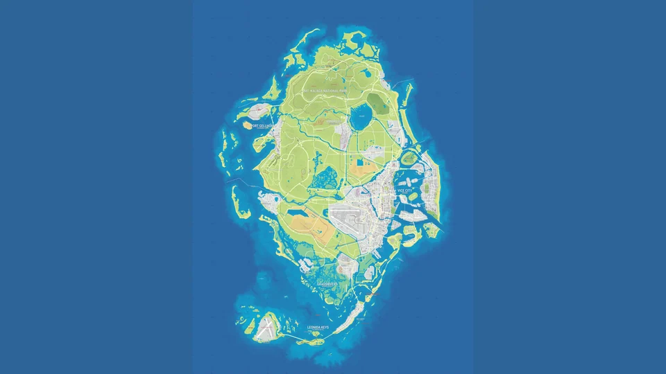
The detailed GTA 6 map that can be examined before release is a fan reconstruction by YANIS. Rockstar has a map too: the company showed a souvenir poster featuring Leonida. But its promotional photograph reveals only part of the reverse, so it cannot reconstruct the entire game world.
Here we examine both images and the interactive State of Leonida map: who made them, where the roads and buildings come from, which symbols help assess accuracy, and where verified information ends. Cartographer Robert, known as lxr, explains the reconstruction method in a PC Gamer interview. The original article’s sources and interface were checked on 13 October 2026.
What YANIS’ Leonida map looks like
Leonida is the state where GTA VI takes place. Vice City occupies only part of that world. Alongside the city, Rockstar’s official website presents the Leonida Keys, Grassrivers, Port Gellhorn, Ambrosia and Mount Kalaga. These are place names in the Leonida section; there is no basis for treating them as six administrative counties. Our Leonida regions article explains their differences.
YANIS’ drawing connects them into a proposed overall geography. In V16, Vice City lies in the east, the Leonida Keys island chain extends south, Grassrivers sits above it, and Mount Kalaga is shown in the north. Port Gellhorn is west of Vice City, with Ambrosia closer to the northern part. These are positions on a reconstruction, rather than Rockstar-published coordinates.
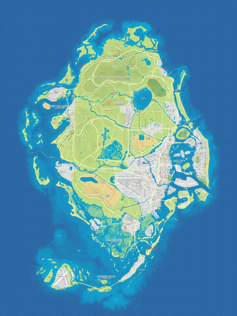
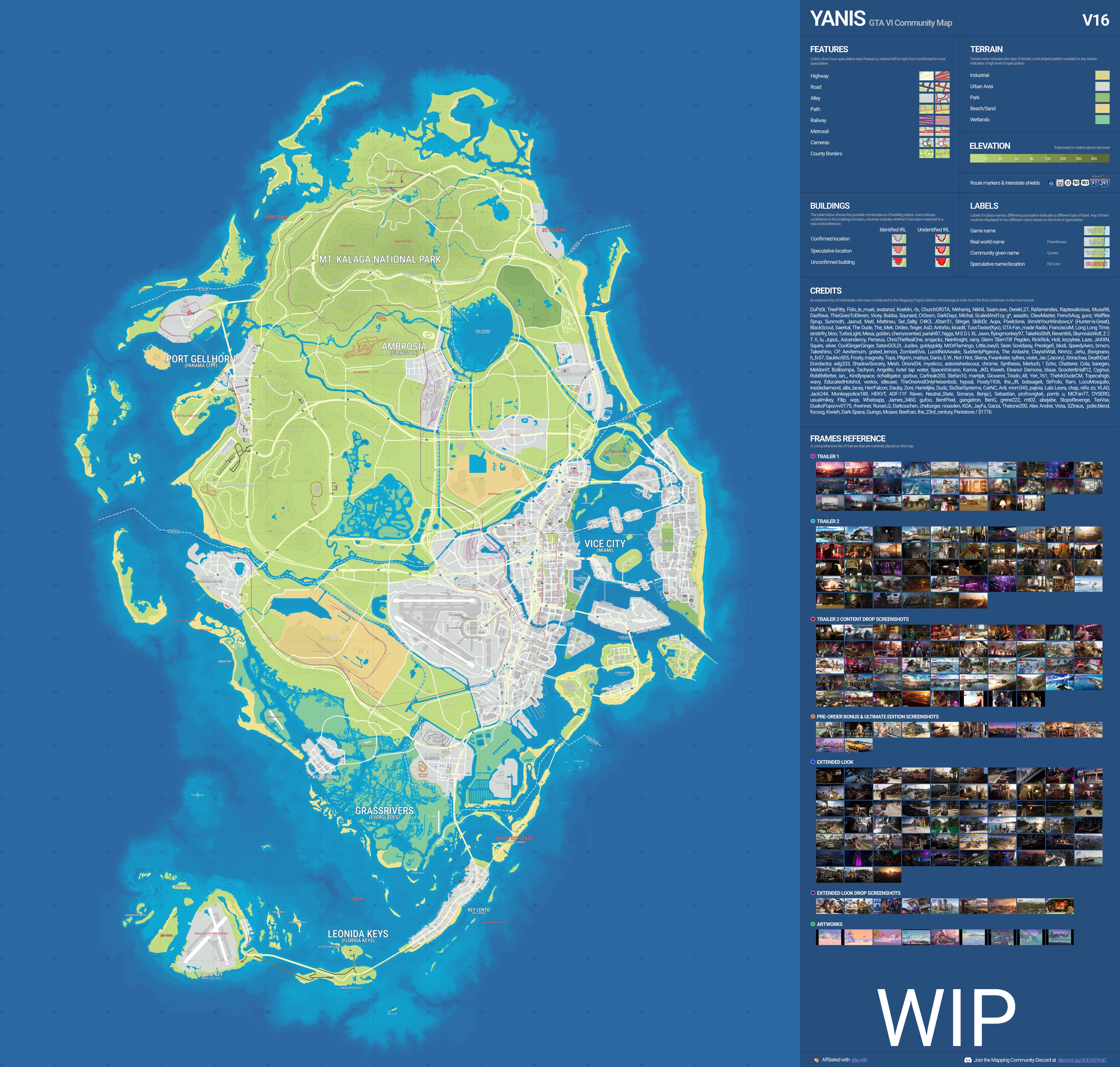
Three labels matter together: YANIS as the author, V16 as the version and WIP as the status. The last means work is ongoing. State of Leonida dates this layer to 20 September 2026. If a similar-looking image says V15 or names another author, it is another version of the map.
The reconstruction has observable reference points its author tries to connect. A freely imagined fan concept might simply show a desired map. A “leak” label claims a different origin and requires separate verification. An image’s appearance cannot establish those statuses: we need to know who published it and what it rests on.
The original V16 file is 4200 by 4000 pixels. It is linked in the sources, allowing small labels to be examined separately. The saved image suits an overview: it shows how the author connects the city, swamps, islands and the northern part of Leonida. Interactive markers and their sources are more useful when checking a particular building.
The official GTA 6 map: what Rockstar showed
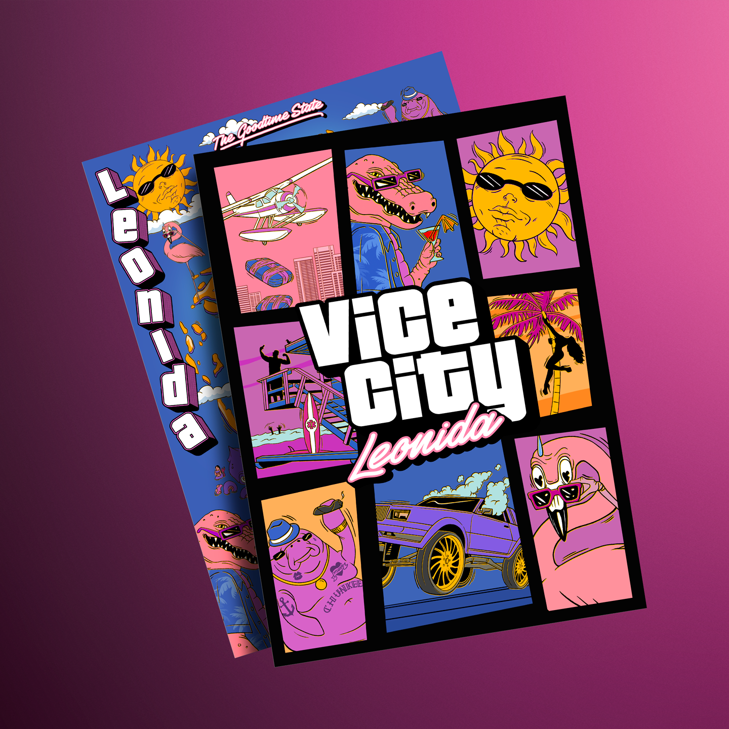
Rockstar Store’s Vice City Collection description explicitly lists a two-sided souvenir poster with a Leonida map. It is an official item. The collection is sold separately from the game, however: including a map does not mean the buyer receives GTA VI.
The promotional photograph places the poster’s front above an image of its reverse. The Vice City illustration covers most of the map. Part remains visible, but the complete road network, scale and territory cannot be read from this photograph. The image’s official origin is established; every souvenir-map contour’s correspondence with in-game geography has not been checked from it.
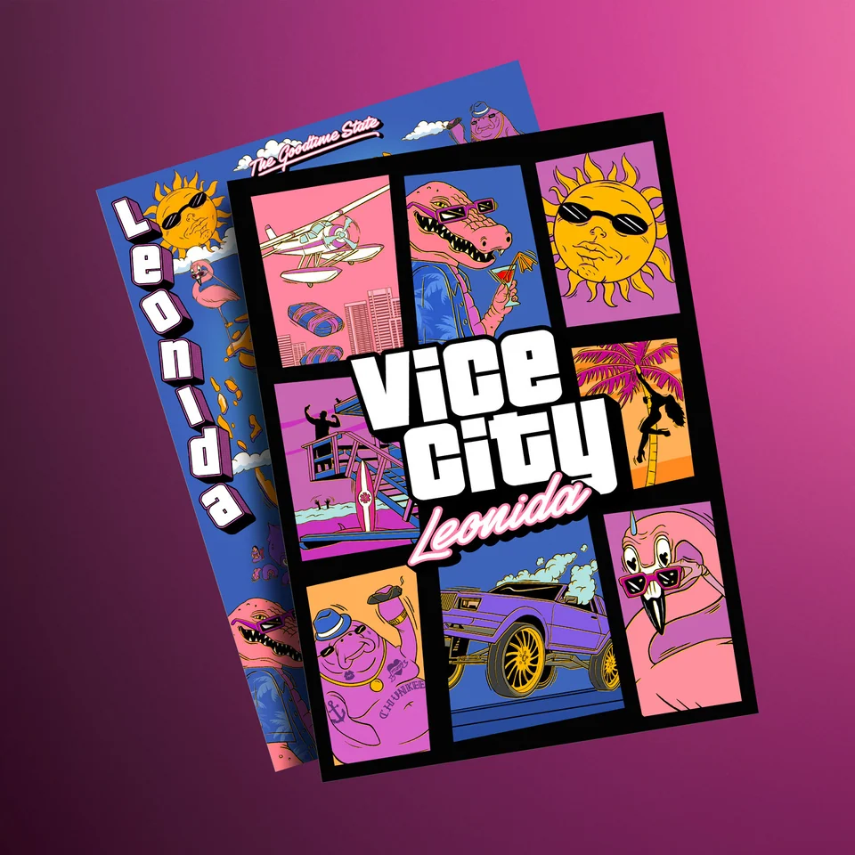
There is also a concrete example of the promotional image changing. On 24 September 2026, user Saukko published a comparison of store photographs. Sandbars and Crude Islands can be read in an enlarged portion of the earlier image, but disappear from the next. Those labels were also absent from the photograph available during the original 13 October check.
This comparison shows a change to lettering in a product image. It does not explain why the image was edited or prove Rockstar removed islands from the game. Conclusions about geography need evidence about the places themselves, rather than different versions of an advertising photo alone.
How a map is assembled from separate images
A trailer shows a street from one viewpoint, a screenshot reveals an adjoining block, and another image gives an aerial view. Cartographers try to align these fragments through shared landmarks. Roads on the drawing emerge from those comparisons; missing sections have to be filled in through assumptions.
In a PC Gamer interview dated 23 August 2025, Robert, known as lxr and involved in the Landmarks Map project, explained the sequence. The team starts with known camera positions from leaked material, places visible buildings, then uses common landmarks to locate cameras from trailers and screenshots. The method’s weakness is understandable too: a small error in one reference point affects later placements.
Finding a real-world model does not always help. In the same interview, lxr described weeks spent searching Panama City’s streets for a building without success. Another member later found it in southern Miami. A resemblance to Florida does not by itself tell people which city to search or where to place the finding on the game reconstruction.
Three-dimensional models are also used to check positions. Cartographer RickRick describes his project as a reconstruction: he imports buildings from Google Earth, places them and adjusts cameras. Such a model lets perspectives be compared, but accuracy depends on camera position, rotation and field of view. It is an author-built model, rather than a map extracted from the game.
The work’s quality therefore depends on its chain of evidence. Several recognisable objects in consistent perspectives provide more support than one similar-looking roof. Even a detailed model retains errors and guesses, especially where source images are scarce.
How to read colours and blank areas
YANIS V16’s legend includes a FEATURES block. Its colours run from elements the author considers confirmed to the most speculative. Another block, TERRAIN, identifies terrain types; red hatching over an area indicates a high degree of speculation. Road colours and landscape colours must each be read against their own legends.
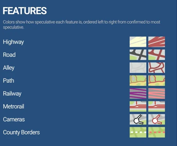
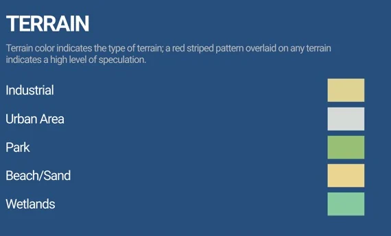
“Confirmed” here expresses the map author’s judgement. For example, an object’s position may be convincingly reconstructed from several images even though Rockstar has not named its coordinates. That is useful support for a reconstruction, but does not give it the status of an official statement.
A blank or simplified area also needs care. It may reflect a shortage of source data. It cannot establish that the game has nothing there. Conversely, a dense cluster of icons does not tell us how many buildings players can enter: a marker records an object or its proposed location, while interior access requires separate confirmation.
A practical reading method is simple: find the area, check the symbols in that version’s legend, then see whether the object has a specific source. Without that basis, the drawing’s detail cannot replace evidence.
Interactive GTA 6 map: finding markers and versions
State of Leonida opens in a browser and lets visitors explore fan maps with markers. Its link is in the sources. During the original check, the interface showed Landmarks, Leaks, Trailer and Screenshots categories, an object list and version switching. These are the service’s data groups, rather than sections of an official Rockstar map.
Here is a search example checked for the original article:
- Open Marker List.
- Enter Ocean View in the search field. The original check returned one entry, numbered L36.
- Expand the entry and select Zur Position, the button taking you to its location. The Ocean View Hotel card opens, and
marker=L36appears in the page address. - Examine the card’s source and images. It links to GTADB, the community marker database used by State of Leonida, and separately offers an in-game image and a photograph of the real-world model.
The game image shows an Ocean View Hotel sign. The card identifies Clevelander South Beach as the real-world counterpart. This explains the marker’s basis. The real-world counterpart and numerical coordinates remain community data: they do not establish the hotel’s official GTA VI address or whether players can enter it.
Versions can be compared using the selected map’s slider. In the YANIS layer, the original research switched from V16, dated 20 September, to V15, dated 23 August 2026, and back. Record the author and both dates first: identical version numbers from different authors do not mean identical maps.
Version differences can relate to source data. GTADB’s author, known as rolux, explained separately that V15 preserves work from before material the community calls the August leak, while V16 incorporates new information. This explains the authors’ approach; it does not confirm that Rockstar verified the leak or the entire reconstruction.
What these maps cannot yet establish
A detailed drawing does not supply an exact world area. A calculation in square kilometres needs a justified scale. A fan model’s coordinates are not that scale by themselves. Comparing image dimensions is equally unhelpful: file sizes depend on how their authors prepared them.
A reconstruction’s boundaries do not prove a second state exists or determine which objects remain in the release build. A name absent from the map or the visible poster portion cannot automatically be declared absent from the game. The image type, version and author’s information all matter.
Comparison with the earlier game needs a separate look at modern Vice City. Bringing back the name does not make the old Vice City map an accurate plan of the new city. The previously published early model should be treated as separate archival material, rather than substituted for the current YANIS reconstruction.
V16 provides a broad spatial reference for getting acquainted with Leonida. To check a specific location, it is more useful to follow a marker back to its source image. The official poster answers a different question: which map souvenir Rockstar offers. Keeping those distinctions intact lets us learn a great deal from the available material without assigning it the accuracy of a finished in-game map.
Sources
- Rockstar: Vice City Collection and poster description, official product photograph, Leonida locations.
- State of Leonida: search, the L36 card and version switching checked for the original article.
- YANIS and contributors to GTADB (gtadb.org): original full-resolution V16 map. Project data and images are available under CC BY 4.0 unless a particular item states otherwise. This article uses the cartographic portion and separate legend excerpts, cropped and scaled.
- PC Gamer, interview with lxr: camera-matching method and the building search.
- RickRick’s 3D project description: models, cameras and limits of accuracy.
- rolux’s explanation of V15 and V16.
- Saukko: report of changed labels, enlarged comparison.