What real city is Vice City in GTA 6 based on?
Miami and Florida inspired GTA 6: beachfront architecture, an island highway, the Everglades River of Grass, and the limits of exact comparisons with Leonida.

Vice City in GTA 6 is based on present-day Miami, while its surrounding state of Leonida draws on Florida. Rockstar took beachfront architecture, varied urban communities, islands, and wetlands from these places. In the game, they have their own names and geography. A familiar view can therefore reveal the inspiration without giving us an exact address on the game map.
What city inspired GTA 6, and why?
The fictional state of Leonida lets Rockstar move beyond a single metropolis and bring together several different visions of the American South.
Head of Development Rob Nelson explained the choice of setting in a Famitsu interview. He was drawn to the variety of people and neighborhoods in modern Florida and Miami. After Liberty City and Los Santos, the team quickly decided to return to this region in a contemporary setting.
That distinction matters. Palm trees and neon recall the older GTA: Vice City, but the new world is built around today’s city. It has its own people, music, ways of earning a living, and ways of displaying wealth. Our separate guide to Vice City in GTA 6 offers a fuller portrait of the in-game metropolis. Here, we look at the origins of its recognizable features.
Miami is recognizable in its neighborhoods and people
The beach setting begins with Ocean Beach. Rockstar’s official description places pastel Art Deco hotels alongside white sand. South Beach and Ocean Drive in Miami Beach provide a clear real-world parallel to that combination.
Miami Beach lies on the coast beside Miami. South Beach is its southern neighborhood, on a coastal island. Causeways connect it to the mainland, including Venetian Causeway and MacArthur Causeway. The familiar image of “Miami with a beach” therefore already combines different parts of the wider urban area: an island strip of hotels and neighborhoods on the mainland.
Ocean Drive has preserved buildings from the 1920s and 1930s, with pastel colors and geometric facades. Beside it stretches Lummus Park, with palms, paths, volleyball courts, and sand. Together, these features make the coast recognizable even without a sign naming the city. In an official Vice City image, the beach is also crowded, with a lifeguard tower and buildings behind it. The image itself does not identify the address of any particular hotel.
Another side of Miami is its Cuban culture. Rockstar mentions busy bakeries in Little Cuba. In the real city, Little Havana is known for Calle Ocho, Cuban food, music, cigar workshops, and a park where people play dominoes. The comparison helps explain the cultural basis of the game neighborhood. It does not mean every activity on that real-world list will be available to players.
A Dazed report on the making of GTA VI describes visits by different Rockstar groups to Miami and its surroundings over the past decade. A separate research team also works in the city. Staff met local people, listened to their stories, and compared what they saw with books and journalism.
According to Senior Art Director of Characters Jamie-Lee Lloyd, that experience helped the team understand the distinctive details of different communities and then reshape them for GTA and its stories. The real-world foundation thus appears in the people on the street as well as in recognizable building silhouettes.
Leonida Keys and the road across the sea
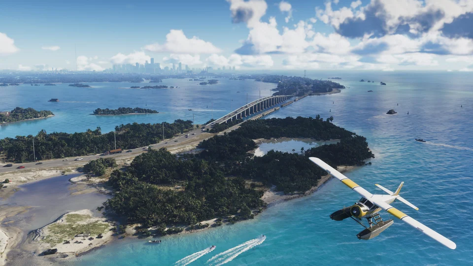
Beyond the city, the island setting stands out most clearly. Rockstar describes the Leonida Keys as a tropical archipelago. Its name and appearance invite a comparison with the Florida Keys, the chain of islands south of mainland Florida. This is a geographic comparison: Rockstar does not name the real archipelago in its official description of the Leonida Keys.
The Overseas Highway connects the Florida Keys. According to the Monroe County tourism authority, the stretch from Key Largo to Key West runs for 113 miles, about 182 kilometers, and includes 42 bridges. The road travels from island to island over open water. That combination of sea, small areas of land, and a driving route sets the archipelago apart from a typical mainland resort.
An official Leonida Keys screenshot shows a similar idea: a road links the islands, cars cross a high bridge, and a lower structure runs beside it. Water fills nearly the entire image, with the city skyline far away. It offers a strong visual reason to compare the scene with the Florida Keys.
The 182 kilometers and 42 bridges, however, describe the real highway. They cannot be carried over to GTA 6. The image also gives us no basis for naming the game bridge after a particular real structure. Its recognizable appearance already conveys the island geography without such an identification.
Grassrivers and the real River of Grass
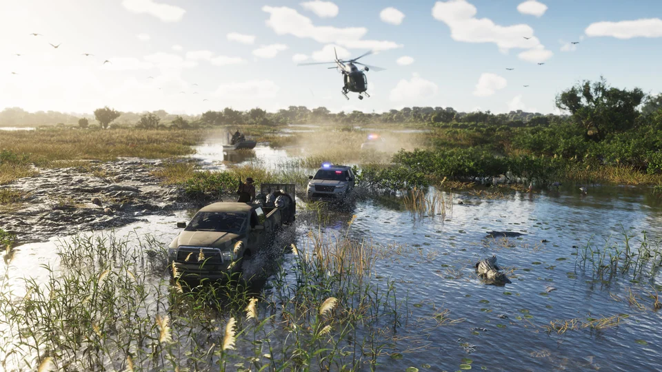
The wetland part of Leonida resembles the Everglades, an immense wetland area in South Florida. Rockstar describes Grassrivers with alligators and mangroves. In an official image, shallow water spreads through the vegetation, with a line of trees visible in the distance. The resemblance comes from the landscape itself.
The Everglades are often called the River of Grass. The US National Park Service explains the expression through the slow movement of a shallow sheet of water across sawgrass. Here, a river need not look like a narrow channel with two banks: water flows broadly across a wetland plain.
There is a small botanical detail too. Sawgrass, despite its name, belongs to the sedge family. It gives a more precise picture of the place than the generic image of “water and trees.” This is a whole ecosystem, with open stands of plants and slow-moving water.
The name Grassrivers contains the words “grass” and “rivers,” recalling the image of a River of Grass. The connection seems meaningful, but Rockstar has not explained the name’s origin. This is our comparison between the real River of Grass and the game wetland, not a developer’s statement about its etymology.
Kalaga, Port Gellhorn, and Ambrosia: the limits of the Florida comparison
Mount Kalaga shows why literal comparisons have limits. Rockstar places the national park near Leonida’s northern border. In a screenshot, a road passes between rocky slopes, a bridge spans it, and forest grows around it.
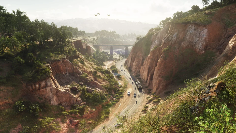
Real Florida is low-lying. Its highest natural point, Britton Hill, reaches 345 feet above sea level, about 105 meters. Those are VISIT FLORIDA’s figures for the real state. Rockstar has not given Mount Kalaga’s height, and the image’s perspective cannot be used to calculate it reliably.
The park’s name and dramatic relief should therefore not become a precise point on a US map. They show how freely Rockstar can work with the image of Florida. Identifying a particular real park as its model would require a separate source; one similar-looking photograph is not enough.
The same caution applies to Port Gellhorn and Ambrosia. In Rockstar’s official descriptions, Port Gellhorn is a forgotten tourist coast, while Ambrosia is an industrial town with the Allied Crystal sugar refinery. Those descriptions do not name the real towns with which people often compare them. For more on the in-game places themselves, see our guide to Leonida’s regions.
A real map can help identify a place, but not a route
There are several levels to the Florida comparison. First is the broad inspiration: Miami and modern Florida, as Nelson explained. Second is the recognizable type of place: beachfront architecture, an island road, and wetlands, which we can discuss using official images and real geographic information. Third is an exact match for a building, street, and neighboring blocks. That requires a separate comparison.
Even a similar facade cannot tell us where to turn, how long a drive to the islands will take, or which building a player can enter. An image shows a scene, not a complete travel plan. Fan-made reconstructions add assumptions about how places relate to one another. Their status and evidence are covered in our article on the GTA 6 map.
Real Florida is most useful as a key to the world’s design: its urban communities explain why a beach is only part of Vice City; its island highway offers a different kind of coast; and the Everglades provide a very different water landscape. In Leonida, these images will meet in one story, while their exact connections in the game remain to be seen.
Sources
- Famitsu, interview with Rob Nelson: the choice of modern Florida and Miami.
- Dazed, report with GTA VI developers: real-world models and field research.
- Rockstar Games, Only in Leonida: published descriptions of places; official screenshots.
- GMCVB, Ocean Drive, South Beach, and Calle Ocho: Miami’s real architecture and cultural geography.
- Florida Keys, Overseas Highway: the real road’s length and number of bridges.
- National Park Service, Everglades vegetation: the meaning of River of Grass and sawgrass.
- VISIT FLORIDA, Britton Hill: Florida’s highest natural point.