GTA 6 vs GTA 5 map: size, cities and world differences
How large is the GTA 6 map compared with GTA 5? The reported twofold difference, Vice City versus Los Santos, RDR 2 and fan map estimates explained.
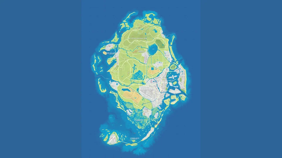
The GTA 6 map should be roughly twice the size of GTA 5’s, according to YouTuber TGG’s account of a meeting with Rob Nelson, one of the leaders of development at Rockstar North. In September, VGC relayed a similar comparison from Aaron Garbut’s Game Informer interview. Fan map overlays produce different figures because they compare different areas and reconstructions. Here is what refers to entire worlds, what refers only to cities, and what could change for players beyond sheer area.
GTA 5 vs GTA 6 map size: what the reported figures mean
GTA V’s world contains Los Santos and Blaine County in the fictional state of San Andreas. GTA VI moves to Leonida, home to Vice City. Comparing the two cities and comparing the two game worlds therefore answer different questions.
TGG visited Rockstar North and watched roughly two and a half hours of Nelson playing freely after the An Extended Look preview. He is recounting a conversation with a developer, not presenting his own measurement of the territory.
| What is being compared | Reported guide | Origin |
|---|---|---|
| GTA 6’s entire world and GTA V’s world | Roughly twice as large | TGG’s account after meeting Nelson; a later similar statement from Garbut in Game Informer, relayed by VGC |
| GTA 6’s world and the Red Dead Redemption 2 map | Roughly three times as large | TGG’s account |
| Vice City itself and Los Santos | Roughly twice as large | TGG and Nelson’s direct remarks in a TroisCouleurs interview |
These figures convey the intended scale, but they are not precise, comparable measurements. The available excerpts do not provide a shared method: which sea, mountains and inaccessible land count, or where each city ends and its surroundings begin. We cannot yet turn “twice as large” into a reliable square-kilometre figure. The origins of absolute estimates are examined in our GTA 6 map size guide.
Vice City versus Los Santos: why city boundaries matter
For GTA V players, the most striking comparison concerns the main city. Nelson told TroisCouleurs that Vice City is roughly twice the size of Los Santos. He then compared the smaller towns and built-up places outside GTA 6’s main city with their GTA V counterparts, citing the number 11.
TGG’s retelling phrases that part differently, comparing Vice City and its surrounding suburbs with Los Santos and its surroundings. The accounts do not match exactly. Nelson’s direct remarks offer no detailed method to establish whether the figure concerns built-up area or the number of settlements. That is why 11 does not appear in the area table above. The discussion concerns places beyond the main cities, but the precise quantity being measured remains unclear. It cannot support a claim that all of Leonida is eleven times the size of GTA V.
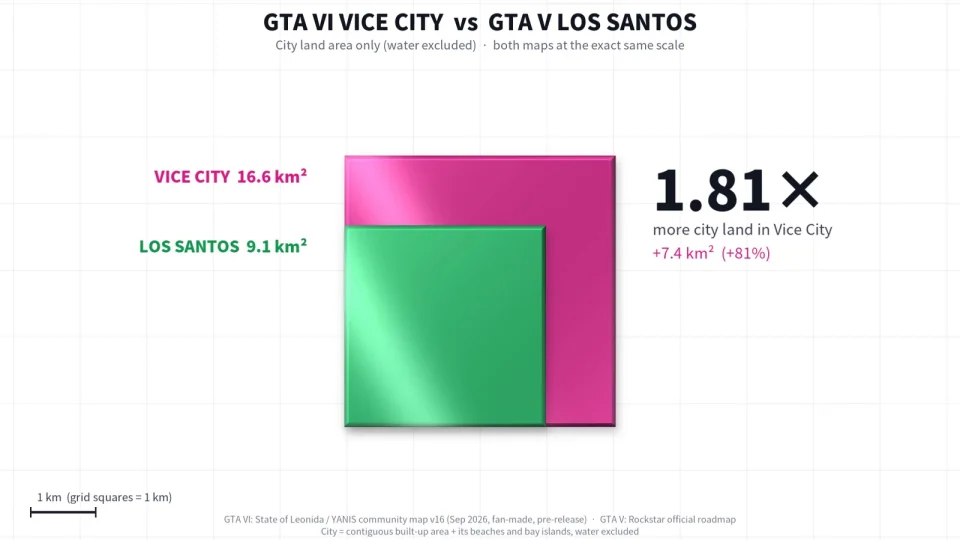
Haykguy’s fan animation shows another side of the problem. The creator overlaid the Los Santos outline on a reconstruction of Vice City, then turned the city silhouettes into visual shapes. At the end, the video labels Vice City as 16.6 km², Los Santos as 9.1 km² and the ratio as 1.81. Water is excluded. These are the video’s creator’s figures and rounding, not our measurements.
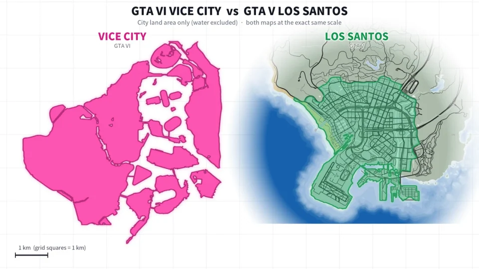
Commenters pointed out missing parts of Los Santos, including Vinewood Hills and the eastern industrial area. According to Notebookcheck, the creator said he traced clearly identifiable urban development and still considers Vice City larger with the additional districts. The objection remains relevant: the result depends on where the boundary is drawn around each city.
The airport raises a separate question. If it belongs in both cities’ outlines, its large runways increase the area without becoming walkable neighbourhoods. To answer “how much city is here?”, it helps to know both the overall area and how much of it consists of streets, homes, industry and water. A silhouette alone is insufficient.
How the world’s layout differs from GTA V
Leonida is more than an enlarged Los Santos with a new name. Rockstar shows a large modern Vice City, the tropical Leonida Keys, the Grassrivers wetlands, coastal Port Gellhorn, industrial Ambrosia and Mount Kalaga National Park in the north. These are six featured places of different kinds and scales, not proof that the whole state is divided into exactly six administrative regions.
GTA V already had a city, countryside, mountains and an ocean. The difference in the new game is therefore worth looking for in the combination of places and the routes between them. An island chain, indented coastlines and wetlands create a different geography from one broad contiguous landmass. A road between points on opposite shores of a bay may have to reach a bridge; a straight line on a map does not show the driving distance.
It matters what has actually been shown. Rockstar’s material does include islands and bridges. The complete road network on a fan map, however, remains a reconstruction, so it is too early to assign a precise journey time from the Keys to the northern boundary. The places themselves are covered in our Leonida regions guide.
There is also an observation about moving between different settings. At a demonstration for TroisCouleurs, a journalist described the cityscape giving way seamlessly to suburbs and then farmland, without the sense of an endless drive. Nelson said the team aims to connect different environments naturally without reproducing the real world at a 1:1 scale. That is an impression from one route, not a measurement across the state.
The scale of streets within the city is changing too. In an October 19 video, journalist Jason Schreier recounted a conversation with Garbut: GTA 6’s roads were made noticeably narrower than GTA V’s. In his account, the plan for tighter streets and denser traffic required more surrounding buildings. This goes beyond simply enlarging the map outline: a familiar manoeuvre between cars may feel different.
At the TroisCouleurs demonstration, traffic on a street already seen before had become noticeably heavier. Nelson attributed the change to rush hour. This is an observation from that specific showing. It helps explain why two trips along the same route may differ, but supplies no fixed congestion factor for the entire game.
GTA 6, Red Dead Redemption 2 and older series maps
Red Dead Redemption 2 provides another point of reference: TGG’s account puts the new world at roughly three times its size. A separate New York Times report, quoted by Game File, ties that ratio to RDR 2’s player-accessible area. This clarifies what is being compared but not the boundaries or method of calculation. Taking an arbitrary RDR 2 area in km² from the internet and multiplying it by three would introduce a new calculation with unknown assumptions.
Nor would that mean crossing GTA 6 takes three times as long. A Western travelled on horseback and a modern GTA travelled by car set different movement speeds. Even with equal areas, travel depends on the vehicle, terrain, curves in the road and stops. Exploration hours cannot be derived from an area ratio either.
The connection to the earlier GTA: Vice City is chiefly the city and Miami’s cultural image. The 2002 game placed it in the 1980s. GTA 6 shows a modern Vice City within Leonida’s much wider surroundings. Bringing back the name does not carry over the old island layout and roads. The new city’s recognisable features are also discussed in our Vice City guide.
San Andreas offers a different comparison. Rockstar had already linked three large cities in one state: Los Santos, San Fierro and Las Venturas. Travelling between distinct settlements is thus not new to the series by itself. The question for GTA 6 is how detailed these places and the transitions between them will be. San Andreas’s city count cannot be compared directly with Rockstar’s six featured Leonida places: a city, an archipelago and a national park are different geographic features.
Rockstar has not announced that the complete maps of older games will return in GTA 6. Liberty City, for example, appears in Lucia’s backstory, but a biographical line does not promise a separate playable map. Leonida remains the setting shown; mentioning Los Santos in a size comparison does not make it a second GTA 6 setting.
Why fan map comparisons reach different results
A fan map is a useful model of what the community has reconstructed from footage, but every model has an author, version and date. The YANIS V17 illustration dated October 17 shows the relative arrangement of city, water, wetlands and islands. It is not a complete official Rockstar map issued for measurements. Our GTA 6 map guide explains how such reconstructions are made.
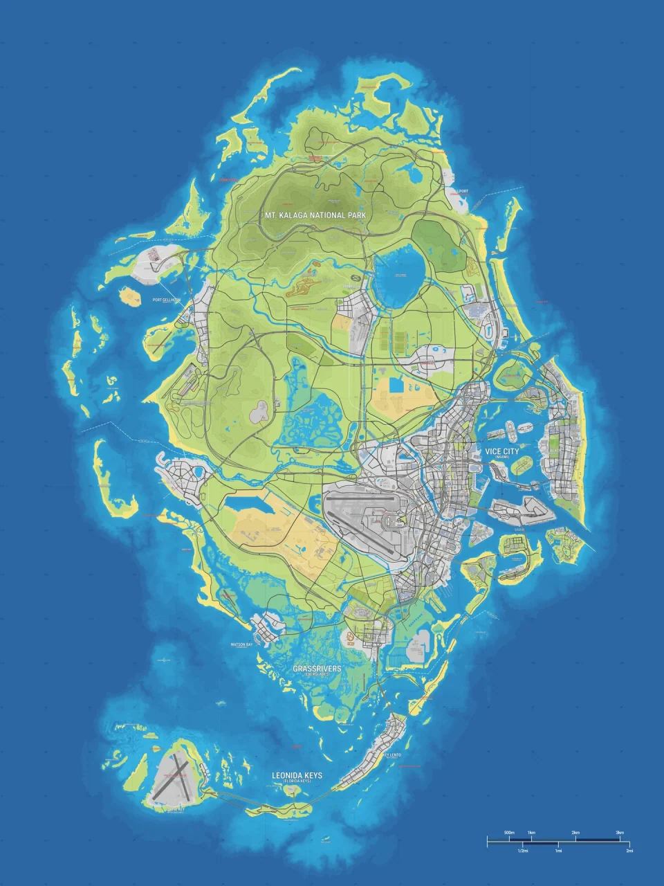
A Reddit post by anli2132 illustrates the different results. For the map used there, the author reported about 2.7 GTA V maps; removing a proposed northern extension brought it to about 2.4. They immediately noted the dependence on an evolving mapping project. This shows how choosing the included territory changes the answer; it does not prove two possible sizes for the released game.
The 1.6 ratio for GTA 6 land versus GTA V land has a different origin. An August CyberMeta article relayed a calculation of land area in pixels. This method can compare two images only if a common scale is justified. Dividing pixel counts alone does not establish that a kilometre on one map equals a kilometre on the other.
There is a subtler trap too. If a shape’s area doubles while its proportions stay the same, each side grows by about 1.41 times. Stretching a map to twice its width and height would instead quadruple its area. An image only a little wider than a familiar GTA V outline can therefore represent a substantial area difference.
Finally, a number can be a conditional multiplication even when it resembles an exact measurement. GTATracker’s 151.68 km² comes from two assumed GTA V maps of 75.84 km² each. The service labels its result calculated, not measured in GTA 6. Its comparison graphic also uses YANIS V13, while its interactive map describes a different version. A polished scale illustration does not remove the need to read those qualifications.
A larger area and a denser world: what else matters
GTA 6 may change not only the distance between places, but how much accessible space each place contains. In relaying Garbut’s Game Informer interview, VGC highlights Rockstar’s attention to rooftops, alleys and interiors. The number of doors players can actually enter is not visible in the area of a flat map. A complete list of interiors and access rules needs a separate examination of GTA 6’s shops and interiors.
Likewise, the ocean should not automatically be called empty or its entire blue border counted as usable territory. Comparing it requires the boundaries of accessible water and knowledge of activities there. Mountain terrain can also cover a large area from above while offering fewer direct roads than a city grid. One ratio cannot describe all these properties of space.
For now, the most meaningful picture has several parts: a world reportedly roughly twice GTA V’s size, a larger main city, clear attention to development beyond it and differently scaled streets. Exact boundaries, comparable areas and journey times will need checking in the game itself. We can already see the direction of the changes if we keep the state separate from the city, a fan calculation separate from a developer’s remark, and area separate from the amount there is to do.
Sources
- TGG, I Saw 3 Hours of GTA 6 at Rockstar North, viewing context at 02:37 and comparisons at 08:52; VGC, August 28, relaying the same meeting.
- Game File, August 27, accessible excerpt quoting The New York Times on the RDR 2 area being compared. The full NYT report was not read for the original check.
- TroisCouleurs, interview and demonstration with Rob Nelson, direct context for comparing cities and built-up places beyond them.
- VGC, September 29, Garbut quotes from Game Informer. The full magazine article was behind a subscription during the original check.
- Jason Schreier, October 19 video, narrower roads at 02:32.
- Haykguy’s comparison and Notebookcheck’s account of the objections, city outlines and excluded districts.
- anli2132’s post, with and without the northern extension; CyberMeta, a separate account of the pixel-based land calculation.
- GTATracker, conditions of its comparison graphic and the distinction between calculated and measured values.
- Rockstar’s Leonida page, Vice City description, official GTA V world preview, San Andreas press release.
- YANIS, State of Leonida, V17 reconstruction dated October 17, 2026; GTADB project data, CC BY 4.0. Geography was not redrawn; illustrations use cropping and scaling.
Images: YANIS V16 maps on the cover and preview, YANIS V17 in the article (CC BY 4.0); two frames from Haykguy’s comparison video.